
Highlights:
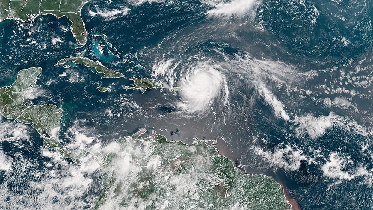
This past weekend, Hurricane Erin exploded in intensity at a record pace, surging from tropical storm status to Category 5 with peak sustained winds of 165mph, before settling as a powerful Category 4 system over the Atlantic. Meteorologists noted that such rapid intensification outside the Gulf of Mexico and so early in the hurricane season is rarely seen. The burst of energy was driven by exceptionally warm seas and atmospheric conditions favorable for cyclonic growth—a stark reminder of the effects of a warming climate.
After briefly weakening during an eyewall replacement cycle (a structural reset that can expand the storm’s size), the hurricane regained strength, widening the zone of dangerous winds and surf now radiating hundreds of miles from its center.
Threat to the US East Coast and Bermuda: Not direct landfall, but deadly water
While Hurricane Erin is projected to remain safely offshore as it curves north-northeast between the US East Coast and Bermuda, its enormous wind field is sending towering swells outward for hundreds of miles. The greatest peril will not come from landfall, but from water: life-threatening rip currents, massive waves, and coastal flooding—especially as high tides are exacerbated.
The National Weather Service office in Morehead City, North Carolina, has issued new beach hazards statements, cautioning, “Even though Erin is expected to remain far offshore, the threat to life from rip currents and high surf along our beaches is very real.” Swells are expected to reach much of the East Coast and Bermuda starting Tuesday and worsen through midweek.
Impacted areas: Outer banks, Puerto Rico, Bahamas, Bermuda
Already, Erin’s outer rain bands have hit Puerto Rico, causing flash flooding and widespread power outages. Over 100,000 residents are reported without electricity. Governor Jennifer González-Colón stated additional rainfall could reach 2 inches through Monday (18) night, with a flood watch remaining in effect.
Further north, Dare County, North Carolina, where the Outer Banks are located, has declared a local state of emergency and ordered an evacuation for Hatteras Island. Coastal flooding and ocean overwash could make areas of the crucial NC Highway 12 impassable for several days, beginning as early as Tuesday (19), and continuing through Thursday (21).
The Turks and Caicos Islands and the southeast Bahamas will also endure heavy rainfall, up to 6 inches, along with flash flooding and landslides. Tropical storm warnings have been placed in these affected regions. Bermuda is set to experience rough seas and possibly tropical storm-force winds by week’s end.
Deadly rip currents: Warnings for beachgoers
From South Carolina to the Delmarva Peninsula and New Jersey shore, officials warn that rip current risks will surge Tuesday through Thursday (21)—even under sunny skies. Historically, rip currents claim more lives annually in the US than lightning, hurricanes, and tornadoes combined, with 44 deaths already this year. Dare County Emergency Management bluntly cautioned: “This is not the week to swim in the ocean. The risk from surf and flooding will be life-threatening.”
With beaches still crowded in late summer, the National Weather Service urges all visitors and residents to obey swim restrictions and rip current alerts to avoid tragedy.
Hurricane season ramps up: Erin is just the start
Erin is the Atlantic’s first hurricane of the 2025 season. Four earlier systems—Andrea, Barry, Chantal, and Dexter—never strengthened beyond tropical storm status. Now, forecasters at the National Hurricane Center are closely watching a tropical wave trailing Erin, with medium chances to develop into another storm in coming days.
Warm ocean waters persist across the Atlantic, with temperatures still well above average, supporting ongoing storm formation. The busiest hurricane period typically runs from mid-August to mid-October, and experts predict above-average tropical activity this year.
Key takeaway
While Hurricane Erin may remain off the coast, the danger is real. Officials urge caution and preparedness as rip currents, dangerous surf, and flooding threaten lives and disrupt coastal communities through the week.